Blog April 2018

WHERE AM I?

Posted On: April 30, 2018

Your on the water, but where am I?

Hey, Pirates never used chartplotters, and their depth finders were lead lines. But they found their way. Take a lesson from them. Bring along a ruler to use with your chart. Using the chartplotter or a GPS position from a cellphone, plot your position on the paper chart as you go along. To plot your course on paper, simply take the latitude and longitude coordinates from the GPS. Find the corresponding coordinates on the edges of the chart. Typically, the longitude coordinates are on the top and bottom edges, and latitude coordinates are on the left and right edges; some chart books have chart views arranged at other angles for space or clarity purposes. Using a straightedge, make a light pencil mark where the lines intersect.

After you've plotted three or four positions, wait 15 minutes or so, then turn off the chartplotter, paying close attention to the compass heading as you do so. Now try to keep track of your position without it. You may not know where you are at that moment, but you'll know where you were 15 minutes ago, and that'll be a pretty good clue. If you know this, you can "dead reckon," which comes from the phrase "deduced reckoning" and means steering by your compass while taking note of your speed and passing time to determine distance traveled. You'll likely find your way to where you want to go, or at least be close. You can also use landmarks, seamarks, and Aids to Navigation to verify and adjust your dead-reckoning position.

Unlocking the navigational clues scattered across your chart won't only add to your onboard fun — it will keep you safer should something knock out your electronics

0

HOW MUCH INSURANCE IS ENOUGH

Posted On: April 27, 2018

How much insurance do I need?

Insurance is designed to protect your boat from loss and to protect you from liability for damage or injury to others. Not having it opens you up to all kinds of potential financial losses.

Most policies have two parts: The one that protects your boat (hull insurance) should provide enough coverage to pay you the value of your boat if it's destroyed, say, by an accident or fire. It will also pay to repair damage from an accident. The other part is called liability, and that protects you from things that you might do to others, such as damage their boat or cause an injury. That amount is typically between $100,000 to $1,000,000, though $300,000 is most common.

The best policies also cover wreck removal in case your boat is destroyed, as well as fuel-spill liability. Talk to your insurance company and it can tell you, based on the purchase price or value of your boat, what amount is right. But make sure you talk to an insurance company that knows boats; homeowners policies often have glaring holes in the coverage.

0

COMPASS BASICS

Posted On: April 23, 2018

Compass Basics

A great article by Mark Corke about the oldest but most important navigational tool.

Many years ago, on my first Atlantic crossing, the only electronic instrument on the boat was an ancient and very temperamental radar. It seldom worked, and when it did, it used prodigious amounts of electricity. Our battery-charging options were limited, so most of the time it stayed switched off, only being brought into service in thick weather or when we were in busy shipping lanes. Navigation was done with a trailed taffrail log, sextant, and chart. But the most useful item on board was the magnetic compass. Sometimes we'd go for days without getting a reliable sight, so we relied on dead reckoning, using the compass course steered and the distance run to estimate a position. Information about prevailing currents and wind direction also helped.


Compasses come in all shapes and sizes, but for the purpose of this article, let's concentrate on the main magnetic steering compass and leave discussion of hand-bearing compasses, gyrocompasses, and other types for a future article.

A Low-Tech Necessity


Compasses, used on boats for centuries, work because a permanently magnetized needle always points to north, irrespective of the position of the boat. Many boaters think that, in these days of modern electronic-charting aids, compasses are no longer needed. Nothing could be further from the truth. A magnetic compass requires no electricity to operate, so it could be the one piece of navigational equipment that still operates on your boat when the proverbial you-know-what hits the fan.


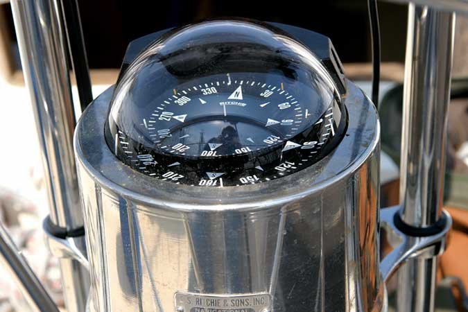
As the boat turns, the compass continues to point at magnetic north, and the course is shown (relative to magnetic north) in reference to a line, which represents the boat's heading. A compass has what is known as the "card," divided into 360 degrees. Thus, if the card reads 90 degrees, you will be steering a course due east; 180, due south; and so on.


For a compass to work well, it has to be correctly installed and properly adjusted. Unfortunately, on a large number of boats, the compass has been installed incorrectly. And with the ever-increasing strain on dashboard real estate, the compass is often pushed out, literally. Electrical interference from chartplotters, radios, speakers, and other electronic aids may affect compasses if they are too close to each other, so an effort should be made to keep these as far away from the main steering compass as possible. A good minimum is 12 inches.


The skipper needs to be able to easily see the main steering compass. This usually means that it must be placed directly in front of the helm position with what is known as the lubber line — two pins or some type of marking — parallel to the centerline of the boat. The skipper merely glances down to see the course being steered.

When North Is Not North


In a perfect world, a compass would always point to true north, but there are factors that make this not so. Two errors have to be accounted for: variation and deviation. Magnetic north is not the same as true north, and this difference is written on the compass rose on the chart of the area you're cruising. This difference, in degrees, between true and magnetic, is known as variation, which must be compensated for when plotting a position.


A nautical chart has two compass roses, one inside the other. The outer one always points to true north, and the inner shows, in degrees and minutes, the variation in the area, either east or west of true north. Variation, which is caused by differences in Earth's structure, differs from area to area and changes by a very small amount each year. This is annotated on the chart inside the inner compass rose. For example, variation changes from about 16 degrees west in Maine to 6 degrees in Florida and 0 degrees in Louisiana.


The other compass error that must be accounted for is deviation. Deviation refers to errors in the compass itself that cannot be adjusted out. Factors that affect deviation include nearby boat electronics, electrical wiring, metal fittings, and radio equipment. Other things, such as the boat's engine, may also affect deviation. Anything magnetic (such as speakers) placed close by will surely increase deviation. To calculate the error in the compass, it must be "swung," whereby the boat is put on several known headings that are checked against the compass reading. This is typically done by lining up a set of transit marks and comparing the boat's course to the indicated reading. Any error is corrected by adjusting the built-in magnets on the compass, which are attached to compensator rods.


Compass fluid damps the needle's responses to sudden movements of the boat. If a bubble becomes visible, have your compass serviced and refilled using a manufacturer-recommended product.


To keep track of compass deviation, you'll need a deviation card, which shows the difference in degrees between the compass reading and the actual course shown on the compass. Compasses that are professionally adjusted will be supplied with a card. But if you do the adjustments yourself, you need to make up your own card. Deviation should be no more than a few degrees on each heading, while variation could be quite a bit more, depending on location. Both deviation and variation (each of which may be added or subtracted) must either be accounted for when working out the plot on the chart or when communicating a compass course to steer to the helmsman.

No-Pressure Practice


Practice steering a compass course rather than following the chart plotter. It takes some getting used to, but when you need it, you'll know how to do it. You'll have more situational awareness and less strain on your eyes. On a sailboat, an added bonus is that steering by compass can keep you attuned to the wind. As the wind shifts, you may be able to harden up or crack off a few degrees, rather than trying to follow that line on the plotter. Novice helmsmen often complain that the compass is constantly moving, but it's worth remembering that the compass does not move. It's the boat that's moving!


A properly installed and adjusted compass is a valuable navigation tool. Buy the best one your budget will allow, and take good care of it. You'll be rewarded with years of service and accurate navigation. 

0

KEEPING YOUR BOAT LEVEL

Posted On: April 20, 2018


Seamanship: Keeping Your Boat Level

The use and abuse of a listing boat.

By Kevin Falvey March 6, 2018  Boating


If everyone aboard rushes to one side to see the whale, the shoreside mansion or the cool boat about to pass, bad things can happen.

Tim Bower

It should be obvious, I suppose, that a boat running level across its beam will ride better. When leaning to one side — listing — a boat is contacting the water on one of the two basically flat hull panels instead of a sharper V shape.

As a result, a listing boat will generally ride harder, and wetter too, because spray will tend to get thrown vertically rather than out to each side.

Listing also induces a turn to the side in which the boat is leaning. This, then, requires more attention to the helm and more physical effort, especially if the boat is equipped with cable steering or is powered by a tiller-model outboard.

A wrinkle involves boats with flat bottoms, which have no water-slicing V shape to speak of. Way back in the heyday of the Jersey watermen, it was discovered that a listing Garvey (the penultimate flat-bottomed boat type) presented its chine corner to the water in a way that tended to smooth the ride. There’d still be the steering issue to deal with, but like boats themselves, techniques of seamanship often prove a compromise of one sort or another.

I’ve seen baymen in my local Long Island waters load a skiff with bivalves so that the gunwales were damn near at the surface of the water. This was on calm days with little boat traffic, and by experienced professionals toiling for their daily bread. Still, listing, even a little, would not have been good. Dipping a rail might have proved tragic.

We recreational boaters have to deal with what might be called a “live load” and therefore need to be at least as careful. A small boat — and I term most boats under about 35 feet as small — with a capacity load of crew aboard pre­sents the opportunity for the skipper to exercise judgment, experience and authority. If everyone aboard rushes to one side to see the whale, the shore­side mansion or the cool boat about to pass, bad things can happen.

First of all, the boat’s going to want to steer to one side — and there’s a boat, a whale or the shore nearby that must be avoided. Second, the listing boat is going to present your crew with a slanted surface on which to stand. Third, the gunwale on the side of the boat to which everyone rushes will get lower to the water. Add in an errant wave or wake of just the right size and at just the right moment, and all three of the boat’s reactions to the movement of live ballast can be affected dramatically, resulting in catastrophe. A tragedy of just this sort occurred aboard a small tour boat in upstate New York some years ago.

I can’t tell you how to speak to your crew. They are your family and friends. And no one can imagine the infinite combinations of wind, weather and situations. What I can say is that good seamanship dictates the need to load our boats with care and see that the load remains secure. That holds true whether the load is a cooler full of ice, bushels of clams, or the people we care about most.


0

MARINE SOLAR PANELS

Posted On: April 16, 2018

The Cost Of Clean Power

Of the three distinct formats of marine solar panels, the aluminum-framed glass panels are the least expensive, as they use a standardized construction process. The semiflexible and walk-on panels are highly specialized items made in small quantities, so they're more expensive. Genuine high-grade SunPower back-contact monocrystalline cells are currently the most efficient ones available and give a higher daily yield, but at a premium price. Amorphous panels are relatively inefficient panels and command a high dollar-per-watt price for their ability to be placed on rounded surfaces.

"There's a world of difference between true high-performance marine solar panels and those used on residential and commercial properties. Prices reflect that. While a small system designed just to stop a battery self-discharging will cost less than $300, a higher-capacity setup will cost in the thousands.


A good rule of thumb? Buy the most efficient panel you can afford. Many environmental conditions (fog, smog, clouds) can reduce the efficiency of solar panels, and if you start with a low-efficiency panel and experience less-than-perfect conditions, you may be unhappy with its performance.

Current output is determined by the quality of the available sunlight. Manufacturers provide efficiency ratings for their panels; be sure the numbers are derived following standard test conditions (STC), which represent the "ideal solar conditions" for maximum performance, so that you can accurately compare one panel to another.

0

MAYDAY WHEN TO SOUND

Posted On: April 13, 2018


How to Radio for Help in a Life-Threatening Emergency

So let’s review as the season starts, a lot of mishaps can occur out on the water, but thankfully most are more inconvenient and embarrassing than anything else. But when lives are on the line – your boat is on fire or sinking rapidly with people on board or someone is in imminent danger of dying without immediate medical assistance – you want every available resource dispatched to your position.

A Mayday call will bring that kind of help. Not only will the U.S. Coast Guard respond but the Coast Guard may notify state and local search and rescue units in your vicinity and ask them to respond as well. The Coast Guard will also transmit an Urgent Marine Information Broadcast over marine-band VHF-FM radio Channel 16, notifying all vessels in the area of your emergency. In many cases a nearby Good Samaritan will be first on the scene to render assistance.

A Mayday – the term is derived from the French venez m'aider, meaning “Come. Help me” – should be transmitted if possible via marine-band VHF-FM radio Channel 16 or 2182 kHz MF/SSB. Emergencies can go from bad to worse in seconds so try to get as much information across in as little time as possible.
 International Maritime Organization protocols call for beginning the transmission with the word "Mayday" repeated three times, followed by the name and number of your vessel and its position. If you have a marine GPS, relate the latitudinal and longitudinal coordinates. If not, state your distance and magnetic or true bearing from the closest navigational landmark. If time allows, you can also relay your departure point, departure time and the speed at which you were traveling. All of these can help rescuers locate you.

0

SOME ANCHORING FEATURES TO MAKE YOUR SEASON

Posted On: April 09, 2018

Seven Important Anchoring Features

Anchoring will be easier if your boat has these seven features.

Based on an article By Joe Friedman


  1. Bow Rail
    For safety, there should be a bow rail on the foredeck. The American Boat and Yacht Council (ABYC) standard H41 requires life rails or lifelines to be 24 inches tall. This rail should be fastened with bolts and backing plates.
  2. Pulpit
    A nice feature on some boats is a molded-in bow pulpit. This allows for the anchor roller and anchor to be positioned well ahead of the bow. A strong pulpit will help prevent the anchor and the anchor chain from damaging the hull during anchoring and recovery.
  3. Cleats
    Cleats should be fastened with backing plates and bolts. The cleat horn should be large enough to handle the rode diameter, including a full turn around the base, a figure eight and a half hitch. As a rule of thumb, Boating suggests cleats be at least 1-inch long for every one-eighth inch of line diameter.
  4. Anchor Locker
    The bow locker should be watertight to the hull; look inside and make sure its bulkhead comes all the way up to the underside of the deck. It should also drain overboard for safety and so that your cabin and bilge don’t stink like bottom mud. A fitting to secure the bitter end of the rode is a plus.
  5. Chocks
    These fittings guide the anchor line off to the side. They’re especially useful if you need to deploy two anchors. Chocks also come into play by keeping the line in one place, preventing your rode from sweeping other hardware — like your navigation light — right off the deck as the boat swings on the anchor.
  6. Bow Roller(s)
    A sturdy bow roller is helpful when a windlass is used. Check the roller to see what type of rode it will accommodate — it may have a rope groove or a chain slot. Also be sure to look for an adjustable pin or bail to prevent the rode from jumping clear of the roller.
  7. Anchor Lock/Chain Stop
    This keeps the anchor in place when stowed in the roller. A pin goes through the chain or shackle. Another type of chain stop is a cable and hook. Yet another is simply a length of line cleated off securely. In any event, never rely on a windlass to hold an anchor, whether underway or at anchor. Always use a chain stop.
0

SPRING CLEANING

Posted On: April 06, 2018

SPRING CLEANING

Okay, so I was watching the TV the other day, dozing in and out of consciousness, when my wife mentioned the office could use a little help.

So I decided to do a little spring cleaning this week. (OK Maybe my wife offered a little motivational coaxing, but I digress). I looked in practically every file drawer and in my storage space to see what we had accumulated, what we needed to keep and what could go.  

I came across one box cleverly marked "miscellaneous junk." It was filled with old papers, faxes, (Remember faxes?), assorted newspaper clippings, research papers and assorted, how should I put this, well, junk!! 

I came across an old newspaper article addressing the increase in Piracy taking place in foreign waters. This article was from 1993. Fortunately we are not knee deep in the piracy investigation business, but as a marine consulting firm we do deal with the effects of piracy.

The US was involved with piracy issues in the Malacca straits and today, still, we are involved in the Horn of Africa piracy problems. The old article shows that in the Horn of Africa, piracy is far from a recent problem, but it continues to be unresolved.

With movies like the "Pirates of the Caribbean" it is hard to believe that piracy is still a current issue, but the world has probably never been free from piracy. While not always glamorous, it seems to span the test of time. It made me think a little.

 Piracy is an ancient and complex problem and the cause of it is oddly related to shore based economics. Only where the shore provides cover to pirates can piracy exist. It is as if a random depraved shore intrudes upon world wide maritime trade. This was the case in the Caribbean, the US East Coast (yes, it was a pirate hot bed too!), the Barbary Coast and every other pirate hotbed before or after. Will piracy ever end?

Doubtful. Not until conditions ashore make piracy economically unattractive. Until then seafarers will have to be on guard.

0